


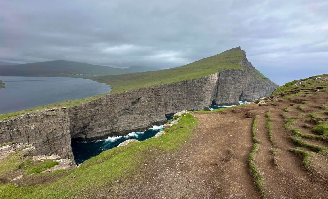
The Sørvágsvatn hike to Trælanípa is one of the most famous walks in the Faroe Islands. And you immediately understand why when you see the view. This is the place where it looks as though a lake is floating high above the ocean. Part optical illusion, part clever viewing angle, but above all simply a very impressive view.
We did this hike on Vágar after our Drangarnir boat tour from Sørvágur. It turned out to be a very logical combination, because you stay on the same island and only have to drive a short distance. First sailing between cliffs and puffins, followed by a walk to perhaps the most famous viewpoint in the Faroe Islands. Not a bad day, you could say.
In this blog, I will tell you everything about the Sørvágsvatn hike to Trælanípa: parking, costs, the route, how difficult the walk is, hiking with a baby, wind, mud and whether the view is worth the 200 Danish kroner.
Contents
Sørvágsvatn and Trælanípa: difficult names, but very famous in the Faroe Islands!
Sørvágsvatn is the largest lake in the Faroe Islands and is located on the island of Vágar. You will also often come across the name Leitisvatn. It is the same lake, but the name varies slightly depending on the village and region. Useful to know, because you will encounter both names on signs, maps and hiking apps.
Trælanípa is the high cliff at the end of the lake. From there, you get the famous view that makes it look as though Sørvágsvatn is hanging above the ocean. In reality, the lake is not hundreds of metres above sea level, but the angle and steep cliffs create this unusual effect.
Even when you know it is an optical illusion, it remains an amazing sight. You look out over the lake, the ocean and the cliffs where the waves crash hard against the rocks. That is exactly the rugged Faroe Islands experience you came for, right?!

Where does the Sørvágsvatn hike start?
The walk starts at a spacious car park near Miðvágur. We could easily park our car here and parking was free. That is always nice, especially at a place where you already have to pay for the walk itself.
There is a small café / building beside the car park. You can get something to drink there and also buy your ticket for the walk. Someone sits behind the counter mainly to sell the tickets, because this hike crosses private land.
There is also a map of the route beside the building. Take a good look at it before you start. It is especially useful to know which directions you can take near the end of the walk, because the route splits there towards Trælanípa and the end of the lake.
How much does the walk to Trælanípa cost?
The walk to Sørvágsvatn and Trælanípa costs 200 Danish kroner per adult. Children up to the age of 15 can join for free. You pay at the small building at the start of the walk.
Is that cheap? No, not really. Especially if you are used to hiking being “completely free”, 200 DKK per person feels quite expensive. But you are walking across private land and this is one of the most famous places in the Faroe Islands.
In the end, we thought it was worth it. Not because the walk itself is extremely spectacular, but because the view at the end is genuinely special. You soon forget about the price a little. Although it is, of course, typically Faroese: beautiful, but not cheap.

Our experience with the Sørvágsvatn hike
We did this walk after our Drangarnir boat tour from Sørvágur. The boat tour was in the morning, after which we drove to the car park for the Sørvágsvatn hike in around fifteen minutes. A nice combination of a morning and afternoon activity, which would otherwise be difficult to fit into the same day.
The weather was rather changeable that morning. It rained at first, but fortunately it cleared up a little afterwards. The weather continued to improve during the walk, although the sky was certainly not completely blue and it was not warm. But hey, we were in the Faroe Islands. You are already happy when you stay dry and occasionally get a beautiful view.
From the starting point, you walk along a well-maintained path. When we were there, it was a little muddy because of the rain, but we also saw that they were adding fresh gravel and improving the trail in several places. That made it perfectly manageable.
One thing that is immediately nice is that you have a view of the lake right from the start. In the distance, you can see the gorge-like opening between the rocks and even the cliff you will eventually walk towards. You therefore quickly know what you are doing it all for, while enjoying a beautiful view along the way.
How difficult is the walk to Trælanípa?
By Faroe Islands standards, we found the walk quite manageable. The path goes slightly up and down, but the elevation difference remains limited for a long time. It is only near the end that you start climbing more towards the cliffs.
We walked for around 45 minutes before reaching the junction. From there, you can choose between walking uphill towards Trælanípa for the famous view or continuing towards the end of the lake and the rocks beside the sea.
Because we walked in both directions, we eventually covered around 8 kilometres. The route is often described as approximately 7 kilometres, but if you walk from the junction to both viewpoints and back, it becomes a little longer.
We spent around two hours on the walk in total, including photography stops and the two side trips from the junction. If you only walk to the famous viewpoint and back, you can complete it more quickly. But I would not rush through it. You regularly get beautiful views towards the lake and the sea along the way.
The wind: do not underestimate it
One thing you should never underestimate in the Faroe Islands is the wind. We did the walk at the end of June, but at the start we were wearing hats, gloves and winter clothing. That might sound exaggerated, but walking into the wind made it feel genuinely cold.
We had a headwind on the way there. You immediately notice that an otherwise fairly flat walk becomes a little more difficult. Once we had warmed up from walking, we did remove our hats and gloves, but we were happy to have them at the beginning.
On the way back, the wind was behind us and the walk immediately felt much more relaxed. The exact same route suddenly feels completely different. Bring several layers, even during summer. A windproof jacket is not a luxury here, but simply standard equipment.

Sheep, birds and views along the way
Naturally, you will encounter sheep along the way. It is still the Faroe Islands, so that probably no longer surprises anyone. Yet they make the walk more enjoyable. They wander around everywhere as if they are the true owners of the island. Every now and then, we heard birds singing or saw them flying overhead.
This is not a walk where every single metre is spectacular. But you are continuously walking through a beautiful landscape. And because you can already see the final destination in the distance, the view slowly builds as you get closer.
The junction: towards Trælanípa or the end of the lake?
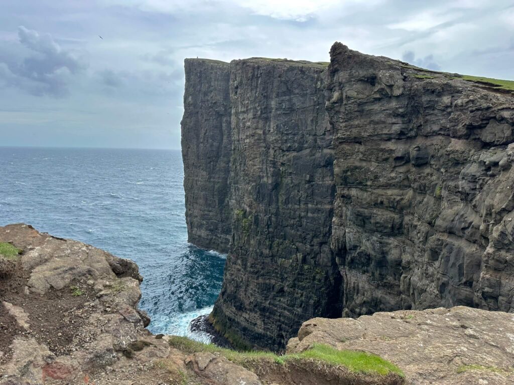
After approximately 45 minutes, we reached the junction. From here, you can walk in two directions. Most people walk uphill towards Trælanípa, the famous viewpoint. From there, you can see the high rock walls, the sea and the famous perspective that makes it look as though the lake is hanging above the ocean.
The climb to the top is a little more demanding than the rest of the walk, but it is still manageable. At the top, you are rewarded with one of the most famous views in the Faroe Islands. You can see the ocean crashing against the high cliffs, with the lake behind you. Yes, this is the picture you came for.
Afterwards, we also walked towards the end of the lake. I would definitely recommend doing that if you have enough time and energy. In principle, you see the same view from above, but we actually thought it looked slightly better from below. You can see a separate rock rising from the sea and get another perspective of the coastline. If you stand very close to the edge, you can also see a waterfall, but we did not dare to do that. And honestly: in the Faroe Islands, you do not need to act tough near the edges of cliffs. The wind will do that for you.

According to the map at the start, you can also walk downhill at the end. We also saw that route listed on AllTrails. But when we were there, it was not really clear where we would have to climb back up again and we did not see anyone following that route. We therefore chose the clear path: first uphill towards Trælanípa and then a separate return walk towards the end of the lake.

The view: the lake above the ocean
And then, of course, there is the view. Because honestly: how often do you see a lake above the sea?
From Trælanípa, you get exactly that unusual perspective. Sørvágsvatn appears to be higher than the ocean behind it. In reality, it is mainly the viewing angle that creates this effect, but that does not make the view any less impressive.
What we especially liked was the combination of the calm lake and the wild sea behind it. On one side, you have the flat water of the lake, while on the other side the waves crash against the cliffs.
You do need a little luck with the weather. When it is foggy or the clouds are hanging low, you will probably see much less. We were lucky that it continued to clear up. It was not properly sunny, but it was clear enough to enjoy the view.
How busy is the Sørvágsvatn hike?
We did not think it was excessively busy. By Faroe Islands standards, it is a popular walk, but if you are used to very busy hiking destinations, it still feels fairly quiet.
The car park is not enormous either, so there is automatically a kind of limit on the number of people who can be on the route at the same time. Everyone also spreads out quite well along the way.
It can be slightly busier at the viewpoints, because naturally everyone wants to take photographs there. But we did not feel as though we were standing in a hiking traffic jam. That is nice at such a famous location.
Sørvágsvatn with a baby or children
We did the walk with our 8-month-old daughter in a baby carrier. And she did not notice much of it, because she slept for almost the entire walk. Nearly two hours, in fact. Apparently, she needed that after the travel day and the boat tour.
This hike is manageable with a baby in a carrier, provided you are reasonably used to walking yourself. You absolutely cannot bring a pushchair here.
I think the walk is also perfectly manageable with older children. It is not technically difficult and children up to the age of 15 can enter for free. You do need to pay very close attention near the cliffs. There are not fences everywhere and the wind can be strong. Hold hands and do not get too close to the edge.
Combining Sørvágsvatn with the Drangarnir boat tour
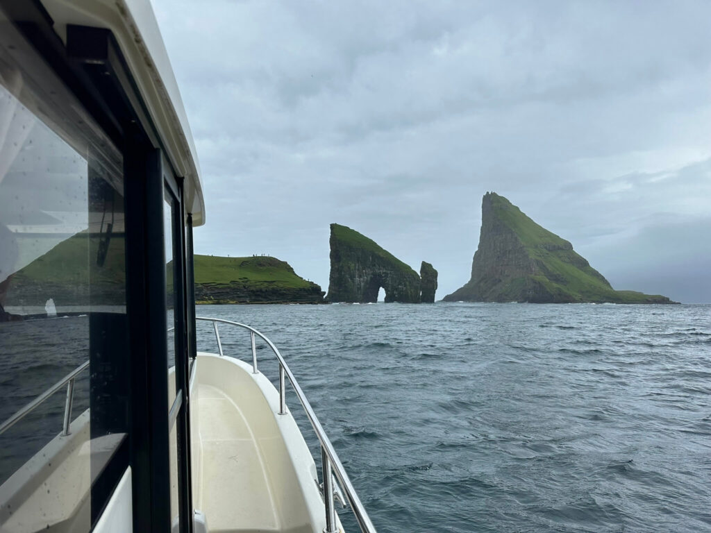
We combined the Sørvágsvatn hike with our Drangarnir boat tour from Sørvágur. We thought it was a very logical way to plan the day. The boat tour takes around 1.5 hours and afterwards you drive to the starting point of the walk in less than fifteen minutes.
This lets you experience two completely different sides of Vágar in a single day. First, you see Drangarnir, Tindhólmur, puffins and Múlafossur from the water. Afterwards, you walk towards the famous view of the lake above the ocean.
Would you also like to do that boat tour? Then read my blog about the Drangarnir boat tour in the Faroe Islands. To book it straight away, you can use this link for the Drangarnir boat tour from Sørvágur.
What else can you do on Vágar?
Vágar is one of the easiest islands for combining several highlights. The airport is located here, along with several of the most famous places in the Faroe Islands.
- Drangarnir: by boat from Sørvágur or on a guided hike.
- Múlafossur: the famous waterfall near Gásadalur that drops directly into the sea.
- Bøur: a beautiful village with views towards Tindhólmur and Drangarnir.
- Gásadalur: small, remote and easy to combine with Múlafossur.
- Sørvágur: convenient for boat tours and close to the airport.
If you only have one full day on Vágar, I would choose the combination of the Drangarnir boat tour, the Sørvágsvatn hike and possibly Múlafossur. It makes for a busy, but very beautiful day.

Staying near Sørvágsvatn and Trælanípa
If you want to do this walk early or combine it with the Drangarnir boat tour, staying on Vágar is very convenient. You will be close to the start of the hike, Sørvágur, the airport, Bøur and Múlafossur.
Miðvágur, Sandavágur and Sørvágur are especially practical locations for this walk. You will be close to Trælanípa and will not first have to drive from Tórshavn. The selection is not enormous, so book in good time if you are travelling during summer.
View accommodation here on Vágar near Sørvágsvatn and Sørvágur. Would you rather stay somewhere central for several days in the Faroe Islands? Then Tórshavn is more practical, although you will have to drive a fair distance for this walk.
Is the Sørvágsvatn hike worth it?
Yes, in our opinion it is. Although 200 Danish kroner per person is expensive for a walk, the view is genuinely special. It is not every day that you appear to see a lake hanging above the ocean.
The walk itself is beautiful and manageable, but it is not spectacular everywhere. Its main strength is the final destination: Trælanípa, the cliffs, the sea and that famous perspective of Sørvágsvatn. When you know that beforehand, you will start the walk with the right expectations.
For us, it was a very enjoyable combination with the Drangarnir boat tour earlier that day. First experiencing the Faroe Islands from the water and then from the cliffs. And despite the wind, mud and winter clothing in June, we thought this was one of the more beautiful walks on Vágar.

Easily book your trip to the Faroe Islands
Flights
Hotels & apartments
Car rental
