
The Clay Cliffs near Omarama are tall rock walls full of peaks and crevices. They look a bit strange, almost as if someone had placed them there by hand. In reality, they were formed millions of years ago by rivers and glaciers, and then eroded by wind and rain.
We made a short stop here during our drive from Clyde to Mount Cook, via the Lindis Pass. That road itself is already beautiful, but the Clay Cliffs make for a really fun stop along the way. It even reminded us a bit of Bryce Canyon in America.

Contents
The Clay Cliffs Are Just a Short Drive from the Main Road
After a short drive on a gravel road, we parked the car and walked to the cliffs in about ten minutes. From there, we suddenly stood among those steep peaks. To be completely honest: it felt a bit like this didn’t belong in New Zealand. We walked between the rock formations up a bit and mainly took some fun photos. Also with the lupines that were in bloom, it was a beautiful spot to visit!
The Clay Cliffs are perhaps not the most famous attraction in New Zealand, but that’s exactly why we found them so much fun. For a few dollars and a short detour, you get a landscape that is completely different from the rest of your trip.

When we were there, the crowds were very manageable. There were maybe three other cars. No buses or masses of tourists, just a handful of travelers.
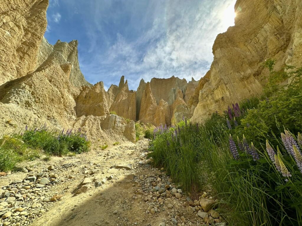
What Actually Are the Clay Cliffs?
The Clay Cliffs consist of tall rock walls with jagged peaks and deep ravines. It looks as if the rocks have been torn apart in pieces. Quite special, because this landscape was formed millions of years ago. Old rivers and lakes left layers of gravel and silt here. Due to an active fault line, those layers were pushed up, and erosion by wind and rain did the rest. The result: a bizarrely beautiful landscape that immediately reminded us of Bryce Canyon in the US.
The Clay Cliffs are “only” 1 to 2 million years old (youngster in geological terms 😉). They were formed by ancient glacial rivers that left gravel and silt here. Due to a fault in the earth’s crust (the Ostler Fault), those layers were pushed upwards. Then wind and rain eroded away the soft parts, leaving those sharp peaks and ravines.

It’s Private Land, So Bring Cash for the Contribution
What is a bit strange, however, is that the Clay Cliffs are on private land. That can happen in New Zealand too. So you have to pay for access. No one checks it, but of course I encourage you to pay properly. After all, you are a guest as a tourist.
- Location: 10 km north of Omarama, South Island New Zealand.
- Access: private land, entry via an honesty box (about 5 NZD per car, bring cash).
- Accessibility: from State Highway 8 you drive onto the unsealed Quailburn Road. With a regular car this is usually fine, but check the road conditions in bad weather.
- Walk: from the parking lot it’s a short walk of 10-15 minutes. Not difficult, suitable for everyone!
Many travelers wonder if the Clay Cliffs are a quick photo stop or if you really need to take some time there. Our experience: an hour is enough, but if you like photography or just want to wander around, you can easily stay longer.

The Lindis Pass Towards Omarama
Before we arrived at the Clay Cliffs, we drove over the Lindis Pass. This is one of the most famous mountain passes in New Zealand and connects Central Otago with the Mackenzie region. The road winds up to almost 1,000 meters and goes right through a barren, hilly landscape.
What you mainly see are rolling hills full of tussock grass. No trees, no villages, just endless shades of brown and gold. In December, the landscape was extra in bloom due to the lupines along the road. After we saw them en masse for the first time in Milford Sound, it was nice to see them again here.
There are a few viewpoints along the road where you can stop for a moment. That’s worth it, because the view changes every time you go around a bend.
After the pass, you descend again towards Omarama. And there, less than 10 kilometers from the village, you find the turn-off to the Clay Cliffs. For us, this was a logical stop: first enjoy the Lindis Pass, then a short walk between the rock formations. It fits perfectly into a day when you’re driving from Central Otago to Mount Cook or Lake Tekapo.
The Clay Cliffs don’t fill a full day program, but they are a really fun stop if you’re on your way (or coming from) Mount Cook or Tekapo. You have to make a somewhat longer travel day if you’re coming from the south (or going further south), and then suddenly those weird Clay Cliffs are there. Well, make the most of it, and go take a look!

New Zealand in Google Maps
We make your road trip easy by sharing 200+ points of interest & 300+ campgrounds in New Zealand with you via Google Maps in just a few clicks.
€ 2.95

